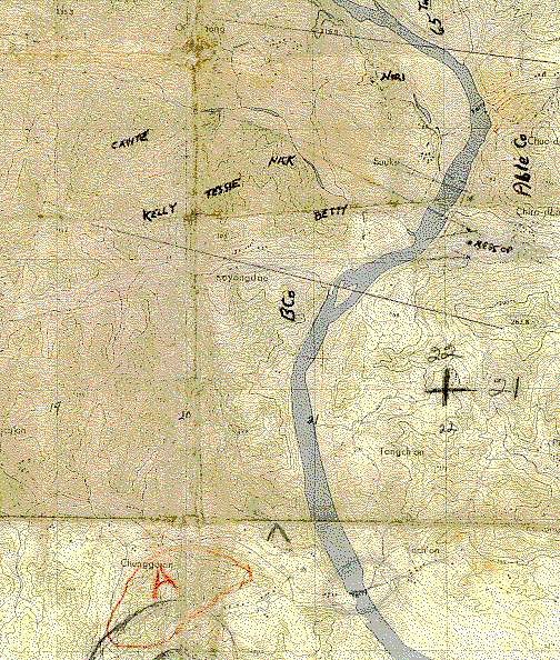
Captain Pearson's Map
Note: Furnished to J. C. Poe (Entry #2)
by Lendon P. Pearson (Entry #11).
Poe passed it on to me with Major (in 1952, Captain) Pearson's
comments.
The map's grid coordinate listings furnished by Sherwin "Arc" Arculis
(Entry #6)
The story that came to me with the map is told below it. MK.
19
20
21
22

23
22
21
20
Kelly CT 197223 - Tessie CT 203226 - Betty CT 210223 - Big Nori CT 215235 - Little Nori CT 216235
The story that came with the map: This is a part of the map that was carried by Captain (now a retired Major) Pearson on his person during all the time he was the Commander of Able Company (15th Inf Rgt) and it was positioned along the Imjin River. That was for most of the time from the beginning of the winter of 1951-1952 until April, 1952, when the First Battalion (15th Inf Rgt) was sent to guard POWs near Pusan. Near the left edge of the map you can see, in red, a big "A" with a circle around it. Of course, it gives a false location for Able Company, about which the Major says, "... was there in case I got killed or captured ...". He added the other hand written markings later on. MK.
MK late add-on (01 Sep 2002): With only a small amount of prodding, J. C. Poe (#2) just emailed me some great info about some pages here and there in the "Can Do" Photo Album and about his own doings East of the Imjin. Here, mostly in my own words, is what I learned from Poe and, also, some things that I already knew:
The mysterious box which is in the Imjin River photo on the page East of the Imjin was located at CT 224236.
The A Co part of the line ran from between the small island at CT 217213 to a draw which ran between the 65th and Able Co. The draw led to the ferry a little bit upstream and at CT 223233. The Belgian Bn was on and around Hill 165, just west of the "Ab" in the written "Able" and at CT 227226 - a supporting position to A Co. All of this seems to agree, mostly at least, with my Corporal Key's Map.
When the 65th got in trouble and part of Co A (certainly not the 4th Squad of the 2nd Plt) went to support them, the action was from a ridge line which ran from a hill located at where the map says "Chiro-dong" (just east of the "Co" in "Able Co" and at CT 228229) down to a bluff on the bank of the river.
Poe says that it was on this same ridge, about half of the way from the hill's top to the bluff, that he went one morning to an unused bunker facing the 65th area to try to get some undisturbed sleep. A new tank platoon pulled into the line shortly after he went to sleep and one of the tanks parked over the bunker with its tracks straddling the bunker. Poe adds: "I think that was the fastest speed anyone ever un-assed a bunker and sleeping bag in the history of the Korean War!!!".
Thanks, Poe.
Late information from Dan Wolfe (#59) tells me that, beginning in late July 1952, the old A Co position became (roughly) that of his L Co, and that I Co was also along the Imjin line and adjacent to L Co on its right - about where the 65th started when it was next to A Co. MK.
![]() 3rd
Division Page
3rd
Division Page
![]() IBB
Map and Photo Index
IBB
Map and Photo Index
![]() Outpost
Kelly Map
Outpost
Kelly Map![]()
![]() Outpost
Nori Map
Outpost
Nori Map![]()
![]() "Our
Hills" from Kelly to Nori - Map and Introduction
"Our
Hills" from Kelly to Nori - Map and Introduction![]()
![]() 65th
Inf Rgt on Kelly - Map and History
65th
Inf Rgt on Kelly - Map and History![]() Corporal
Key's Map
Corporal
Key's Map
![]()