Near Dagmar and Beyond Nori
MK intro (15 Oct 2002): John Clark
"Hi, Merv.
I
have been trying to find the town/location of the I Co raid that I was on during the
night of 8/15/52. The aid station records say that a nearby town was Chok-Ke-ri. I can not find it on
any of the submitted maps.
Also,
I have found pictures of me and two other guys taken near Dagmar. I will get several of those pictures redone/copied and send them to you.
Maybe someone will be able to recognize one of them. I sure would like to
remember their
names and find out if they are still alive. Be expecting
the pictures in about a week or so - maybe you could put them on the web site. I'll be
the skinniest one. John Clark."
For non-Bunker folks, I need to say that
Dagmar and Little Gibraltar are some of the commonly used names for the twin-peaked
Hill 355.
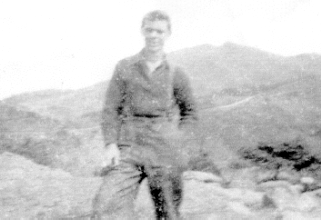
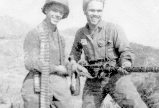
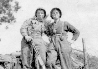
Now I will show you John's photos and an
excerpt I found from the 15th Inf Rgt casualty lists. John is the man in the top photo and is the middle man in the
right-hand photo just below that.
 CLARK JOHN H
Rank= PFC
Serial Number= RA12377500
State of Record= NJ
County of Record= Middlesex
Race= 1 Year of Birth=
1934 Branch= Infantry
MOS= (4745) Light
Weapons Infantryman
Assigned Unit= 15th Inf Regt - 3rd Inf Div
Place of Casualty= N Korea
Date of Casualty (Year/Mo/Day)= 1952/08/15
Casualty Description= WIA by
missile
Hospitalized - Returned to Duty (FECOM)


John also wondered about the when and who of his photos.
That was no surprise to me because that problem usually comes
up whenever I post photos in the "Can Do" photo album - even mine
 . After I got the
photos, asked some questions, and numerous emails were passed back and forth, I came up with
this version of what John remembered about the photos:
. After I got the
photos, asked some questions, and numerous emails were passed back and forth, I came up with
this version of what John remembered about the photos:
"All
the pictures were
taken at about the same time and while the 3rd Bn was in a position on the
MLR near Hill 355.
Hill 355 is clearly visible in the
background of the picture of me alone and in the background of the picture directly below the one of
me alone.
"You
can see that those two pictures were taken some distance apart by the
fact that the picture of me alone was taken much farther from Hill 355 than was the other. In
the picture of me alone may be seen a road going up a rise (small hill); and, in the
other picture, may be seen another part of the same road going down that same or another
small hill and beginning to fork.
"I
remember that the left branch of that fork
led to the area of the Co I CP (Command Post) on the MLR. There was a saddle to
the immediate east of the Hill 355 peak and to the east of that saddle was our
CP,
"I also remember that, at the time the pictures were
taken, I Co had an Australian unit nearby and somewhere to our left. When we
got our beer ration, the Aussies would sometimes come over and try to trade
their liquor (rum or ?) for our beer - which they didn't get.
"The left
branch of that fork was also used by a half-track with quad guns when it would
come to upset the Chinese and me too. When we were on the front line there, the
half-track used to pull up near our bunker and fire into
the trenches out in front of us, then pull out and take off. When it did that,
we caught hell for awhile from incoming mortars trying to get the half-track.
ANYONE remember that?
"I
think that the right branch of that fork may have been used to supply the other
outfits on the MLR and to the east of Co I."
In spite of the fact that
all of the photos had "Korea 2/52" marked on them before my ill
advised "crop" job, two things are
certain: they could not have been taken earlier than April of 1952 or, with the
exception of the photo with the bunker in it, any place close to the MLR. Otherwise, the guys in the photos would have had
much warmer clothes on their bodies and would have had steel pots on their heads.
In April of 1952, right before the entire 3rd
Div fanned out to various locations in the rear, the 2nd Bn of its 15th Inf Rgt was
positioned on Hill 355 with the Australian units to its immediate left. G Co was on
the peak and the other two rifle companies of the 2nd Bn were on the eastern slopes
of Hill 355. The Hill 355 area was the
most western part of "our hills". The 1st Bn was on the MLR from the
Outpost Kelly area to the northeast and the Imjin River, and then on across and
along the banks of the Imjin past the valley and Outpost Nori. Able Co (and
I) of the 1st Bn were
on the MLR from where it crossed the Imjin to just across from Outpost Nori. The
Nori area was the most
eastern part of "our hills".
Therefore, using what John has said and what
else I have learned from
several guys in the Bunker (credits at the bottom of this page), it is now clear
that the 3rd Bn, including John's Co I, was then located on the MLR
from beside the eastern slopes of Hill 355 to the northeast where the area of the 1st
Bn began, and that John's Co I was on the extreme left of the
3rd Bn sector of the MLR.
Also, I will assume, until I am corrected by an add-on
from some kind soul, that the photos were taken during late April of 1952 and
from behind the 3rd Bn position on the MLR, possibly when Co I was in Bn
reserve.
The page "Our
Hills" 1951-1952 Map has a view of the entire area of "our hills". The page
West of the Imjin has two photos furnished by (Lawrence) Leland
Harper (#65) of Co I. Those two photos were taken from only slightly behind the
MLR position of Co I and with the camera pointed in the
direction of Hill 317 instead of Hill 355. Donald Elmer
(#69) of Co L has made a drawing (not a map) of the forward hills he could see
from the MLR. It's on the page Don and
His Buddies.
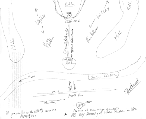
Of course, John's main puzzlement was about
the exact "where" of the events of 15 Aug 1952. Seeking help in the name of the hill,
John drew this map and snail mailed it to Leland, who scanned it and emailed it on
to me. The layout of the MLR along the Imjin and of the hills across it are much
more accurate than one would expect after a fifty year delay. I didn't do much
better when I drew my Corporal Key's Map in "real
time" - my only excuse being my cold fingers. Here is John's map:
To aid his quest, John also emailed me
something like these snippets:
"Looking
at the pictures
already on your web site, I remember the small knoll across the river and a small
part of the range of hills on each side of the valley, but I don't
recognize the hill we attacked way up the valley.
"The
hill was way out in the valley and like slightly to the right looking at it from
the MLR.
"I remember F-86's dropping BIG
bombs on that hill for several days in a row in an attempt to knock out a cave
suspected to be used for storing supplies to be distributed to surrounding
hills. From the MLR, we saw
small arms fire bring down one F-86.
"Also, we had some long poles that had large charges on the ends to
throw into the caves went we got to them,
but that never happened. The Chinese let us go half way up that hill before
they set up a line in back of us and had us in a cross fire."
There was much more back and forth between us
and peering at photos and maps. Finally, John studied the page "Our Hills" from
Kelly to Nori and decided that Hill 135 fit the bill exactly for the hill he
was on when he was wounded. The  was
solved!!!!!
was
solved!!!!!
The good part about all that back and forth
between John and me is that, while it was going on, he would drop in snippets
about the events of 15 Aug 1952. I saved them all and here is a rearranged, but
only slightly edited, version of what John told me.
"The
road or path out started from the knoll straight out for a ways. I believe it
curved around some to the right and maybe even back again before we got to the
hill.
Trying to make something fit (short) on paper never comes across as you did it. Again, it was dark also and most of us played follow the leader
out there. The same is true on the way back except for my small swim in the rice
paddy from which someone else came out and pulled me back up on that path. WHOEVER that was, I thank with all my life,
I didn't at the time because I couldn't see or
hear anything. Must have taken 15/20 min to regain my senses.
"The aid/hosp records say
'wounded by missile
- shell fragment'. That is not correct.
"We were instructed not to leave ANYONE on the hill even if he
was dead - to bring back everyone. That's what I was doing coming back on that path with two
other guys. One guy was between the wounded guys legs we were carrying (face up,
as he had a belly wound) and I had a hold of his left arm & the other guy had his
right arm. I felt something hit my leg, I looked down and saw it go off under
the guy we were carrying so I know it was a Potato Masher. You know what that
was. Don't know who the other guys were or how they made it out, but I am sure the
guy we were carrying didn't make it as he got the full blast. Don't even remember
letting go of him, but I was out in the rice paddy a good distance from the
path. It was a long walk back to the outpost.
"I left by chopper right after the raid.
I remember getting back to the knoll and I think I got a shot for the pain
as my right leg was about double it's size from walking that far on it. I
remember dragging it on the last part of getting back as my knee wouldn't bend.
From there, a few of us we were first taken to the rear by a small chopper and then
were taken by a large chopper to a big tent like they showed on MASH. All I remember was a long line of bright
lights in that tent. From there, it was to Ta-Gue(?) in the middle or so of
South Korea - or, wherever."
Here is a drawing made in "real time" by
Donald Elmer (#69). You will notice that it was drawn from about the same
vantage point as John used when he drew his map - fifty years later, of course.

Although John's map was drawn from the vantage point of Co L's
position on the MLR in August of 1952, it is clear that the regular position of
John's Co I at that time was just to the right of Co L and farther upstream
along the Imjin. John remembers that his platoon went to the rear to practice
for the raid of 15 Aug 1952 and then went to the place where he drew the map
only "a short
time" before the raid took place. He also remembers that there was a full
moon out and about so that the raid was delayed for a few days. It seems logical
to infer that, during a part of that time, John and some of the other Co I men who were scheduled to go on the raid
may have spent a few days with the men in Co L.
For the information on this page about the location of the
15th's units on the MLR during April of 1952, I necessarily relied on Sherwin
Arculis (#6), Pat O'Conner
(#21), Ray Flaherty (#24), and
Dan Wolfe (#59). I was never west of Kelly except
for my Two Trips to Breadloaf. That will be the
title of a page on which, when the mood hits me, I will tell the stories that go
with it. Please, someone, remind me to make the link here when the dastardly
deed is done.
 3rd Division Page
IBB Map and Photo Index
3rd Division Page
IBB Map and Photo Index
IBB
- Page Seven 
"Can
Do" Photo Album